
I swear, I was getting sick of those navigation apps. Every time I hit a new city, my battery screams bloody murder before lunchtime, or the GPS decides I’m walking through the middle of a shopping center when I’m clearly on the street. So when I had to make a trip up to Leicester last month—a place I hadn’t been to in years—I decided I was ditching the tech. I was going full analogue: paper map only.
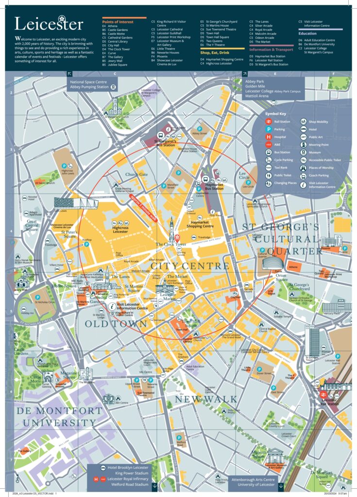
I went straight to the information kiosk and grabbed one of those proper, detailed city center maps. You know the kind. They’re usually printed on heavy, glossy paper and they are absolutely massive when you fully unfold them. The sheer volume of little lines and tiny street names instantly made my head swim. It looked like someone had thrown spaghetti at a board. My initial thought was: how the heck am I supposed to read this detailed map without taking an hour?
The First Step: Orienting Myself and Finding the Spine
The first practical step I took was forcing myself to ignore all the details and find the big stuff. I laid the map flat on a coffee shop table and started scanning for anchors. For Leicester, this meant finding the two massive, unmissable features: the River Soar and the main ring road—the A594, I think it was. These things are the structural bones of the town; they never move. By finding them, I immediately partitioned the entire chaotic map into manageable quadrants.
Next, I had to pinpoint exactly where I was standing. This is where most people mess up—they look at the destination before finding the starting line. I checked the street sign right outside the coffee shop, found that name on the map, and then used a small, blunt pencil to draw a tiny ‘X’ right there. Now, the map wasn’t just a piece of paper; it was a representation of the ground right under my feet.
I also realized I needed to establish North. Unlike the phone which rotates the map for you, the paper map is usually fixed. I used my actual little compass (yes, I carry one, it’s reliable) to figure out which direction the map’s North arrow was actually facing relative to the table. I physically rotated the map until North on the paper faced North in reality. Suddenly, the whole thing clicked into place. Everything made sense spatially.
Deconstructing the Route and Using Landmarks
My target was a small bookstore near the Highcross Shopping Centre—a place known for tricky little side streets. I wasn’t going to let those little lanes beat me.
I traced the route with my finger first. Instead of trying to memorize every turn, I focused only on major changes and significant landmarks. I realized I could walk down the High Street until I crossed the big blue line (the river), then keep going until I saw the gigantic Clock Tower, and only after passing the Clock Tower would I make the critical turn onto the side street.
I started breaking the journey into chunks, almost like pit stops:
- Get from X (Start) to the River Soar bridge. (Action 1: Straight line).
- From the bridge, walk until the Clock Tower. (Action 2: Visual confirmation).
- At the Clock Tower, turn right onto the side road. (Action 3: Specific turn instruction).
This process of breaking down the overwhelming details into three or four simple visual checkpoints made the map go from confusing reference document to a clear travel itinerary. I wasn’t relying on street names, which are tiny and hard to read while walking; I was relying on enormous physical structures I couldn’t miss.
A trick I picked up years ago, which really helped, was the ‘folding trick’. Once I had my route identified, I folded the rest of the map away. I only left visible the small section covering my current location and the next two blocks. This massive map suddenly became pocket-sized and manageable, eliminating all the visual noise and distraction from the south side of town where I wasn’t heading.
Hitting the Pavement and Validating the Method
I took off walking. Because I had oriented the map earlier, I didn’t second-guess my first few steps. I kept the map folded tightly in my hand, referring to it only at the major decision points—like crossing the river. When I saw the river exactly where the map said it would be, my confidence shot way up.
Walking toward the city center, I saw the Clock Tower looming exactly as the map indicated it should. I checked my folded section, confirmed the turn, and made the right hook onto the small street. I didn’t fumble, I didn’t backtrack, and I didn’t stop to stare confusingly at a tiny phone screen under the bright sun.
I reached the bookstore precisely on time. No detours, no wasted minutes searching for a signal, and critically, my phone battery was still at 90% when I got there. The key to reading those detailed maps easily isn’t memorizing every street name; it’s identifying the huge, unmissable features that act as milestones and forcing yourself to ignore everything else until you hit that next milestone.
It was a massive relief, honestly. Being forced to use the paper map made me actually look up and interact with the physical environment of Leicester, rather than just staring down at a glowing rectangle. I felt genuinely navigated, not just towed along by an app. It’s rougher, sure, and takes five minutes of preparation, but the independence it buys you is worth every second.